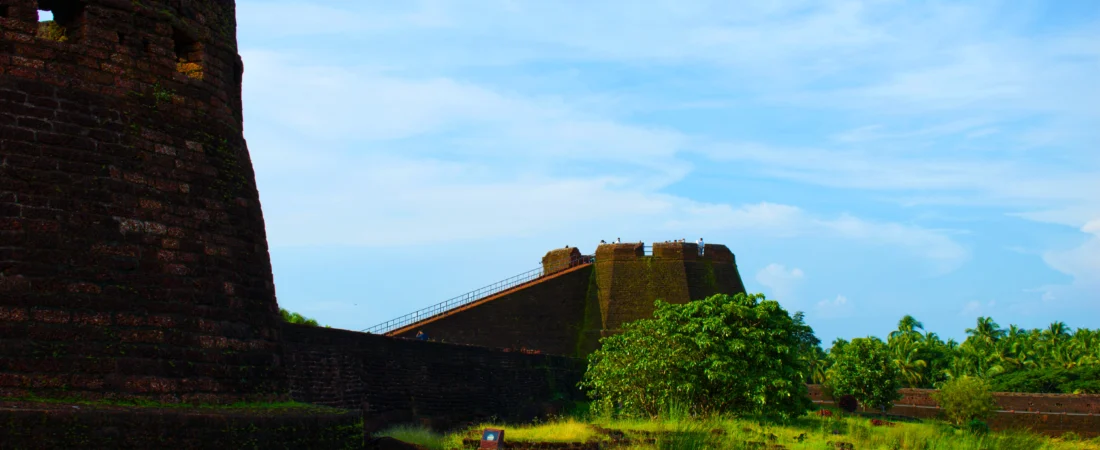
Most forts sit on hills and look down at the land they were built to protect. Bekal Fort does something stranger. It walks out into the Arabian Sea.
Nearly three-quarters of its outer wall is in contact with water. Stand on the beach at Pallikkare and the laterite ramparts seem to grow straight out of the waves — forty acres of fort on a headland, walls about twelve metres high, the whole structure rising some 130 feet above the sea. It is the largest fort in Kerala, and I’d argue the most photographed spot in Kasaragod district, though most of the photographs never get around to asking the obvious question: who actually built this thing?
Because the honest answer is: it’s disputed. And the dispute is more interesting than the postcard.
Two Stories of Bekal Fort
The version you’ll hear most often is clean. After the Vijayanagara empire collapsed following the Battle of Talikota in 1565, its former feudatories rose in its place, and among them the Keladi Nayakas of Ikkeri became the power on this coast. Hiriya Venkatappa Nayaka began fortifying Bekal, and Shivappa Nayaka completed the fort around 1650 — the same building programme that gave Kasaragod its Chandragiri fort. Bekal became the Nayakas’ base for dominating, and later defending, Malabar.
But there’s an older layer underneath. Bekal’s recorded history as a place goes back before the 12th century, when it was an important port town under the Kolathiri (Chirakkal) rajas — and Kerala Tourism’s own historians note that opinion is divided: some credit Shivappa Nayaka with building the fort outright, while others hold that the Nayakas captured an existing Kolathiri fort and rebuilt it as their military base. There’s even a community angle to the Nayaka period — the Koteyar or Ramakshatriya families found around Bekal and Panayal are said to have been brought to this coast by the Nayakas specifically to man and defend the fort.
So the fair way to say it is this: what stands today is substantially Shivappa Nayaka’s fort of around 1650, possibly raised over something older that the Kolathiris had begun. Every ruler who took it afterwards is believed to have reworked it to suit his own military thinking, which means the fort you walk through is really several forts, layered.
Built for War and Nothing Else
Here is a detail I find quietly revealing: Bekal was never an administrative centre. No palace, no durbar in the standing structure, no mansion for a governor. It was a machine for defence, and everything about it says so.
The entrance zigzags, so attackers could never charge it in a straight line, and a wide trench wraps around the landward side. The fortification runs in two lines with fifteen bastions of varying shapes. And the sea-facing walls carry one of the smartest touches I’ve come across in a Kerala monument — openings cut at two different heights. The upper holes were for aiming at ships far out at sea; the lower ones for striking an enemy who had come close. Range-finding, built into the masonry, four centuries before anyone said the word ballistics.
Inside, the essentials of a garrison under siege: a water tank with a flight of steps cut down to it, giving the fort its own perennial supply; a magazine for arms; a tunnel opening towards the south; and at the centre, the observation tower attributed to Tipu Sultan, from which you can still see Kanhangad, Pallikkara, Bekal, Mavval, Kottikkulam and Uduma laid out along the coast. Whoever held that tower saw every sail on this stretch of sea before it saw them.
The Hands It Passed Through
The fort’s later history reads like a summary of South Indian power itself. Hyder Ali of Mysore conquered the Nayakas and took Bekal in 1763. Under his son Tipu Sultan, the fort became a key military station for the Mysore campaign to take Malabar. When Tipu fell at the Fourth Anglo-Mysore War in 1799, the British East India Company took over, and Bekal became the headquarters of Bekal Taluk in South Canara district — the administrative arrangement that would keep Kasaragod attached to the Kannada country for the next century and a half, and which explains a great deal about why this district speaks the way it does today. With the reorganisation of states in 1956, Bekal came home to the newly formed Kerala.
Then, gradually, the port declined, the garrison logic evaporated, and the fort settled into being what it is now — a monument in the care of the Archaeological Survey of India, declared a special tourism area in 1992.
What the Ground Remembered
For me, the most underrated chapter in Bekal’s story is the newest one. Between 1997 and 2001, the ASI ran four seasons of excavation inside the fort under archaeologist T. Satyamurti, and what came out of the ground changed the picture of what this place had been.
The digs exposed buried residential and palace complexes, a durbar hall, a temple complex — and a mint house. Over two thousand antiquities were recovered: coins, terracotta seals, metal objects including gold, most of it dating to Tipu Sultan’s period. The coins belonged to Hyder Ali, Tipu Sultan and the Mysore Wodeyars, and among the finds was a copper coin mould of Tipu Sultan himself.
Sit with that for a second. Coins were being struck inside Bekal. This wasn’t just a wall with cannons on it; for a period under Mysore, it was an economic engine of the region — a place where money was literally made. Almost none of the tourist material mentions this, which is a shame, because it’s the detail that turns Bekal from scenery into history.
If You Go
Bekal is about 16 km south of Kasaragod town on NH 66, with its own railway station (Bekal Fort) plus Kanhangad and Kotikulam nearby; the closest airports are Mangalore, roughly 70 km away, and Kannur, about 100 km. The fort is open from morning to 6 p.m., and the two ends of the day are when it’s at its best — early morning for clear light and empty ramparts, late afternoon for the sunset, which from the observation tower is genuinely worth planning around. There’s very little shade inside, so carry water and wear proper footwear; the laterite surfaces are uneven.
Near the fort stand an old Anjaneya temple with stucco images of the gods on its walls, and a mosque believed to have been built by Tipu Sultan — the two of them side by side, which locals will point out to you as a fact about this coast that needs no elaboration. If your visit lands in March or April, the Rama Navami festival at the Mukhya Prana temple brings Kathakali and Yakshagana performances to the fort itself.
And yes — if the ramparts look faintly familiar, you may be remembering the song ‘Uyire’ from Bombay, which was shot here, as was ‘Dwadashiyil’ from the Malayalam film Madhuranombarakattu. The film crews found what the Nayakas found: there is nowhere else on this coast quite like it.
Bekal is what Kasaragod looks like when it decides to be monumental — which, in this district of small shrines and village theatres, it rarely does. Go for the walls and the sea. Stay long enough to think about the coin mould, and about how many different flags watched the same sunset from that tower.
Kerala-born and raised, Bengaluru for the career, and Coorg has been home for the last decade. Lithin writes Unfold Kerala to explore — and stay connected to — the state’s history and culture. Follow the photography on Instagram @lithinphotography.